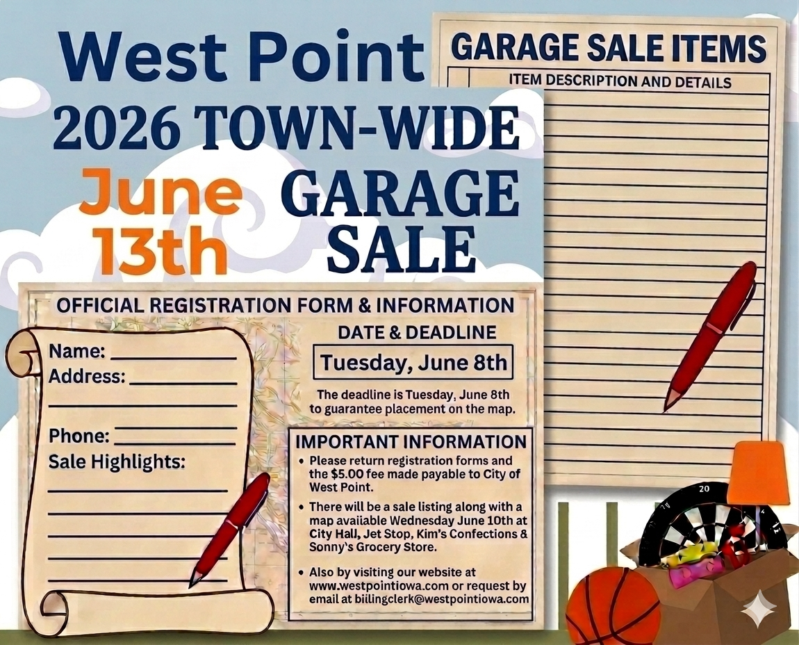
Our Location
LOCATION
The historic community of West Point, which was settled in 1834, is nestled in Lee County in the southeast corner of the great State of Iowa. This predominately German community with a population of nearly 1,000 sets on a hill 9 miles inland from the Mississippi River. The original woodland, serving as hunting grounds to the Sauk and Fox Indians, bridges the south-side of the community. The prairie lands, which are now some of the richest farming land in the Midwest, lie to the north.
HIGHWAY TRANSPORTATION
Three new U.S. Highways belt the community of West Point. Scenic highway J-40 (old 103), which runs through West Point and passing City Square Park, connects with U.S. 27 to the west (10 minute drive), and U.S. 61 to the east (10 minute drive). In addition, county highway X23 which runs north to south and also passing City Square Park connects with U.S. 34 to the north (20 minute drive). U.S. Highway 27, also known as “Avenue of the Saints,” runs north to south from St. Paul, Minnesota to St. Louis, Missouri. U.S. Highway 61 which also runs on a north to south route paralleling the Mississippi River originates in Canada above Lake Superior and terminates in St. Louis.
OTHER MODES OF TRANSPORTATION
Amtrak, with stations in downtown Ft. Madison (15 minute drive), downtown Burlington (40 minute drive), and Mt. Pleasant (20 Minute drive) links residents with national passenger rail service. Burlington Municipal Airport (30 minute drive) provides Lee County residents with daily air commuter service. Additionally, Cedar Rapids/Iowa City International Airport, an easy 90 minute drive on new highway 27, provides access to numerous major airlines. Nationally known carriers provide cargo and package express services, from all of the above referenced locations. The Quad Cites of Davenport, Bettendorf, Rock Island, and Moline are a two-hour drive north on highway 61 while Quincy, Illinois, is slightly more than an hour to the south and also provides Regional Airport Service.
DISTANCE GUIDE
Local Area: Communities within a 25 mile radius of West Point
Community Distance from West Point Population
| Burlington/W.Burlington | 25 | 30,000 |
| Danville | 19 | 914 |
| Denmark | 10 | 400 |
| Donnellson | 12 | 963 |
| Farmington | 22 | 756 |
| Fort Madison | 9 | 10,715 |
| Franklin | 6 | 136 |
| Houghton | 12 | 130 |
| Keokuk | 24 | 11.427 |
| Middletown | 17 | 386 |
| Montrose | 15 | 957 |
| Mount Pleasant | 23 | 8.751 |
| Nauvoo, Illinois | 20 | 1,108 |
| Pilot Grove | 8 | 25 |
| St. Paul | 6 | 118 |
Midwest Area: Cities located within reasonable driving distance from West Point.
Distance represented in road (interstate) miles according to www.aaa.com
Community Distance from West Point Population
| Des Moines (Iowa) | 185 (2 hrs 45 min) | 193,187 |
| Chicago (Illinois) | 270 (4 hrs 45 min) | 8,449,180 |
| St. Louis (Missouri) | 205 (3 hrs 30 min) | 348,189 |
| Kansas City, Missouri) | 280 (5 hrs) | 1,751,140 |
| Minneapolis (Minnesota) | 375 (6 hrs) | 382,618 |


